Fyrefly Alpha
An EFB built for fire-aviation pilots.
Real-time weather, ADS-B traffic, FAA-sourced charts and airport data, NWCG-aware dispatch zones, automated FRAT, and a tamper-evident audit trail for compliance with NTSB Part 830, FAA Part 91.103 / 135.69, and USFS contract recordkeeping.
What Fyrefly is
Fyrefly is an in-development electronic flight bag focused on the unique needs of helicopter and fixed-wing pilots flying for federal and state wildland fire operations. We are building it alongside active fire pilots so the surface area matches the work they actually do — initial-attack dispatches, helicopter-coordinator coordination, drop runs, retardant base operations, and air ambulance missions in mountainous terrain.
It is a progressive web app that runs on iPad / iPhone, Android, and any desktop browser. There is no installation step; the app is served from app.fyreflite.com and works offline once a pilot packs their route for a flight.
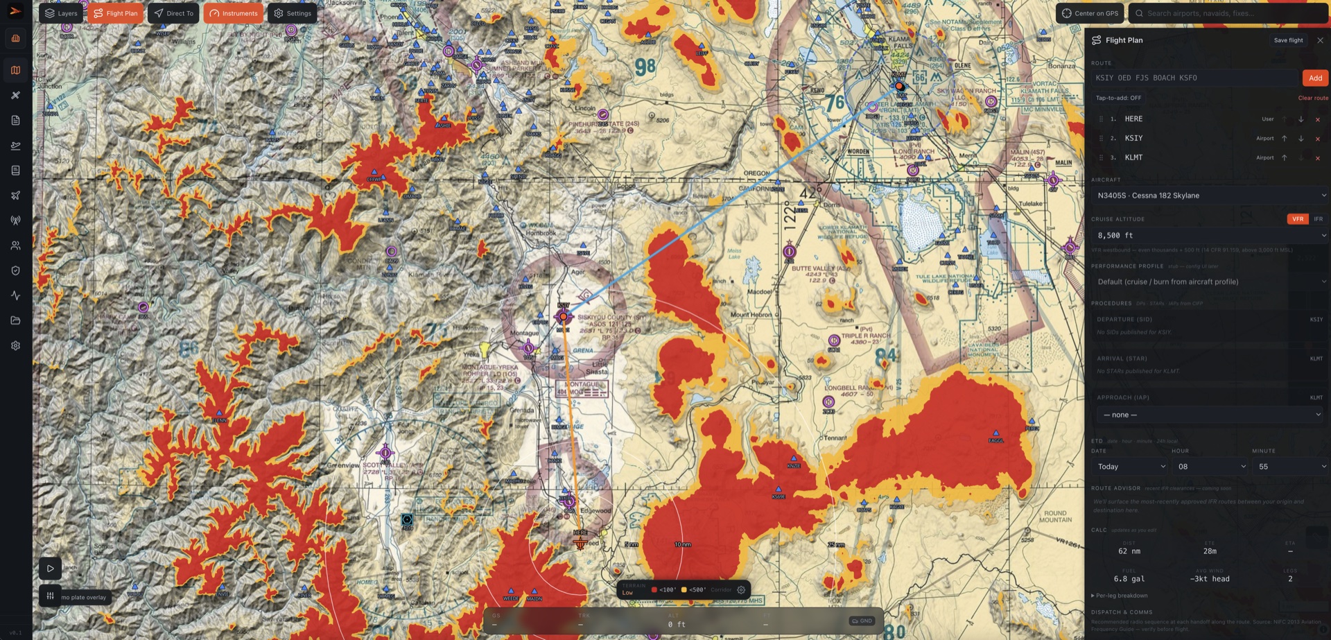
What's working today
FAA-sourced charts + airport data
NASR APT.txt full ingest (manager, fuel grades, lighting, services, attendance, remarks), TWR / AWOS frequencies, CIFP procedures, d-TPP plates.
Live weather
NOAA AviationWeather METAR / TAF / AIRMET / SIGMET / GFA / CWA, HRRR + GFS winds aloft, WPC surface analysis, NEXRAD mosaic.
Terrain advisor (TAWS-like)
Per-pixel SGSL DEM colorization at altitude, configurable hazard buffer, mountainous-time logbook accumulator from the recorded track.
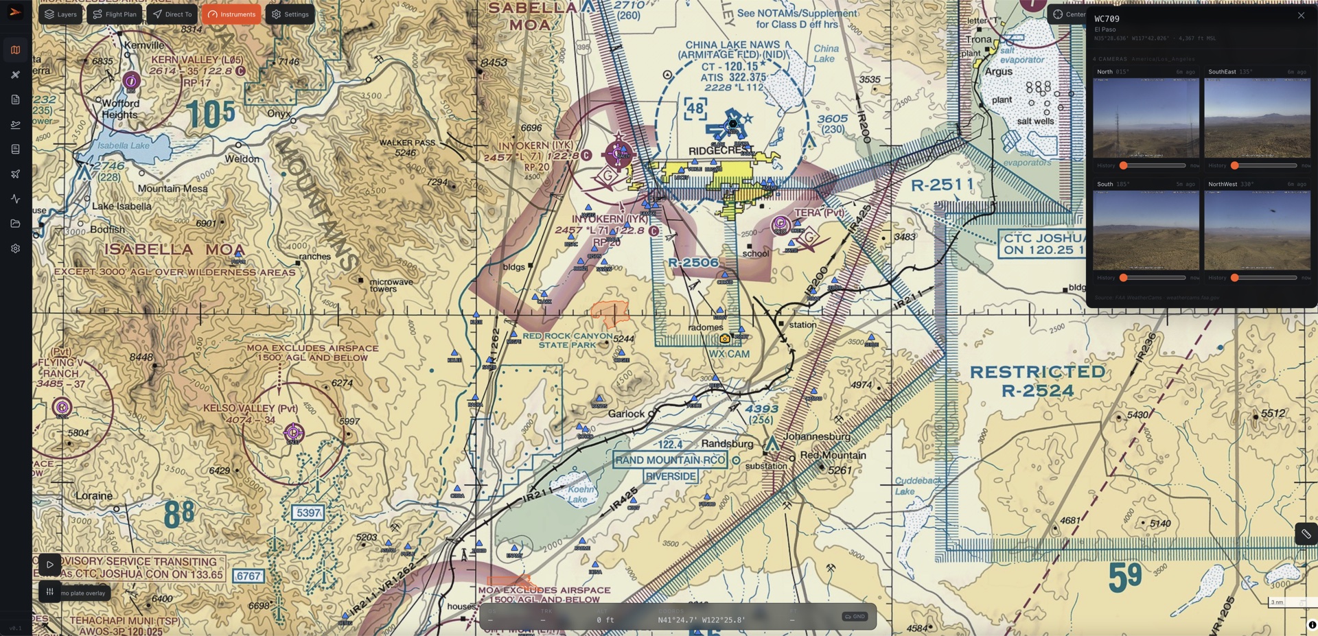
Wildland-fire awareness
WFIGS active fire perimeters + VIIRS hotspots, NIFC dispatch zones with boundary-crossing alerts, IRWIN-linked incident management.
FRAT + risk briefings
USFS-style flight risk assessment templates (HAA, CWN Type-3) with auto-fill from live wx + pilot currency + route data. Hash-chained audit log of every sign-off.
Multi-org operator support
One pilot, many operators. RBAC for invited crew + chief pilots + finance roles. Magic-link invite flow for new crew.
Active partnership outreach
Fyrefly is actively seeking partnerships with providers of the data sources our fire-aviation customers rely on — panel avionics manufacturers (for in-cockpit GPS, AHRS, ADS-B, and flight-plan transfer over Bluetooth), satellite-tracking and flight-following services, federal flight-following programs, and the wildland-fire incident-data feeds that program managers and dispatchers depend on.
In each case we are an open, well-documented, FAA-data-driven endpoint that can ingest the provider's signal, render it in a cockpit-appropriate UI built specifically for fire pilots, and write it back into the tamper-evident audit log that satisfies NTSB Part 830, FAA Part 91.103 / 135.69, and USFS contract recordkeeping. Provider integrations we are pursuing include:
- Panel-to-tablet wireless connectivity for in-flight GPS position, AHRS attitude, ADS-B In traffic, and FIS-B weather — so Fyrefly works as a true backup display on tablets that don't have built-in GPS or independent AHRS.
- Bidirectional flight-plan exchange with panel navigators, including SID/STAR/IAP procedures and direct-to commands.
- Satellite tracking and flight-following platforms for beyond-ADS-B coverage in remote and high-terrain fire traffic areas where ground-based surveillance is sparse.
- Federal flight-following service feeds for participating mission profiles (search-and-rescue, government-contract, wildland-fire dispatch).
- Wildland-fire incident-data feeds (perimeters, dispatch zones, retardant drops, TFR rings) so on-task fire pilots see the live mission picture without leaving the chart.
- Post-flight track-log import for the operator's flight records and the audit-log requirements above.
If your program offers a developer SDK or partner integration path, we would like to apply.
FAA-recognized data sources
Every primary data layer in Fyrefly traces back to a source the FAA considers authoritative. We do not author or rebroadcast weather, airspace, or chart data — we display official government feeds.
- Charts & airports — FAA NASR (APT.txt, TWR.txt, AWOS.txt), FAA d-TPP (approach plates), FAA CIFP (procedures), 28-day update cycle
- Weather — NOAA Aviation Weather Center (METAR / TAF / AIRMET / SIGMET / GFA / CWA), NOAA HRRR + GFS (winds aloft), NOAA WPC (surface analysis)
- Airspace — FAA TFR feed, NASR special-use airspace, real-time NOTAMs
- Fire data — NIFC WFIGS (perimeters, dispatch zones), NASA FIRMS VIIRS (hotspots)
- Imagery / terrain — USGS National Map (DEM), NOAA radar mosaic
Compliance
Fyrefly emits a tamper-evident audit log of every pilot decision the operator may need to defend at audit: weather briefing generated, FRAT signed, flight plan committed, TFR acknowledged, aircraft and crew assigned. Each event is hash-chained (SHA-256, per-user) so a post-hoc edit anywhere in the chain is detectable. Per-operator retention is configurable from 3 years (FAA Part 135.69 minimum) to 10 years (federal-contract retention).
Who we are
We are a team of experienced fire-industry contractors and aviators interested in making firefighting aviation safer and more effective — to protect our communities on the wildland-urban interface. The Fyrefly roadmap is informed by direct feedback from working fire-aviation pilots, both rotor and fixed-wing, operating in California, Oregon, Washington, and Idaho under state and federal wildland-fire contracts.
Contact
- info@wildfiremedical.com
- App
- app.fyreflite.com
- Phone
- Available on request